 CPS Resource Centre
Boliva "War of the Pacific" Historical Borders Issue
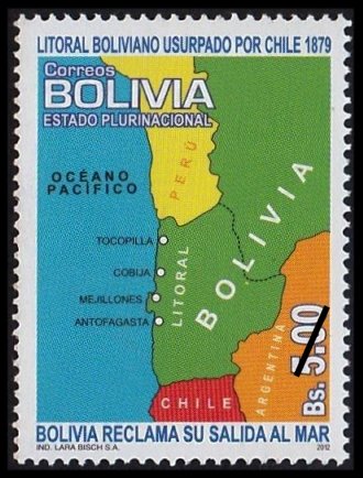
Bolivia 2012-03-12
Correos Bolivia has issued a new map stamp on March 12, 2012. The 5.00 Boliviano denominated stamp shows Bolivia’s borders, extending to the Pacific Ocean, as they were in1879 at the start of the “War of the Pacific” or “Saltpeter War.” When the war ended in 1884, Chile had taken control of the Litoral region and Bolivia became a land locked country. There are a few other Bolivian stamps depicting these border changes. [any additional information or an improved scan is welcomed –web admin]
Belgium Mini-sheet Commemorates Mercator and Hondius

Belgium 2012-03-12
A new two stamp mini-sheet was issued by Belgium Post on March 12, 2012 to mark the 500th anniversary of the birth of Gerhard Mercator. The “Rate 3” denominated (€ 7.14) sheet features two stamps, the left one of Gerhard Mercator and the right of Jodocius Hondius. The background of the sheet appears to be an image of the “NOVA TOTIVS TERRARVM ORBIS GEOGRAPHICA AC HYDROGRAPHICA TABULA,” published in 1633 by [i believe] Hondius’ son Henricus. Hondius helped to re-establish the reputation of the work of Mercator, through the reissue and expansion of a series of previously published Mercator works. This is another fine looking cartophilatelic item for 2012.
German Post Marks Quincentennial of Mercator's Birth
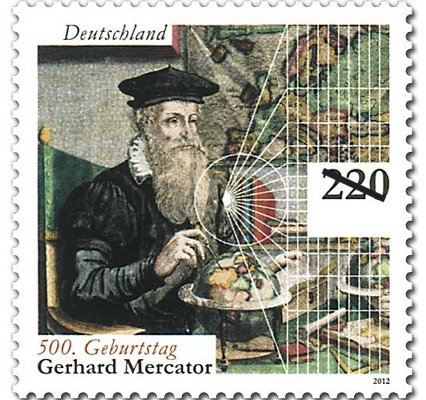
Germany 2012-03-01
The 500 year anniversary of the birth of Gerhard Mercator on March 5th was marked by German Post with a new high denomination stamp. The€2,20 square format issuefeatures an image of Mercator in the foreground holding what appears to be a pair of calipers placed on a small globe resting on a table. In the background, is a map of Europe and a series of white construction lines radiating from a single point forming what appears to be the graticule of the famous Mercator projection.“Mercator was born Gerard de gemor or de Cremer in the Flemish town of Rupelmonde, Mercator is the Latinized form of his name. It means merchant”. In 1554 he completed a large six panel map of Europe, with a second edition in 1572. Originally created by Erhard Etzlaub in 1511, Mercator refined the techniques and used the projection in a large world map, published in 1569. The projection had parallel lines of longitude to aid navigation by sea, and compass courses could be marked as straight lines. It was this projection that now bears Mercator’s name. Mercator was also thefirst person to use the term “atlas” for a collection of maps. Mercator started production of an atlas that was not fully published until after his death in 1594.
[ in searching around on the internet, besides a number of articles celebrating Mercator’s birth, i found a very interesting item which indicates that there is an error in this stamp. if anyone has some additional information regarding this, please contact the web admin.]
New Caledonia: XIV Pacific Games

New Caledonia 2011-03-18
On March 18, 2011, New Caledonia’s Office of Posts and Telecommunications issued a single 110F denominated stamp to mark the [then upcoming] XIV Pacific Games that took place from August 27 – September 10, 2011 in Nouméa. New Caledonia was the official organizing host nation for the 14th gathering of the Pacific Games. The design of the stamp depicts an oblique like view of New Caledonia and the Loyalty Islands with a series of points that could indicate event venues or points along the torch relay. The NC 2011 logo is shown in the bottom left corner of the stamp. In the top center, Joemy, the mascot of the games is shown in the air above the islands holding the torch. Following the curvature of the globe, Joemy’s motto “Pacifique Attitude” is written. New Caledonia obviously demonstrated a lot of “Pacifique Attitude” as evident in the final medal standings. Congratulations to all the participants and the organizing committee! [ upon first glance the view of the islands and position of the mascot appears quite similar to a previous New Caledonia issue and favorite of cartophilatelists, sc#322. –web admin ]
New Caledonia: Ouvéa Atoll, UNESCO World Heritage Site

New Caledonia 2011-08-08
On August 8, 2011 New Caledonia’s Office of Posts and Telecommu-
nications issued a single 75F denominated stamp with a map of the Ouvéa Atoll, part of New Caledonia’s UNESCO World Heritage Site. The stamp depicts a sea turtle on a sandy beach, with vegetation and a bird flying overhead. A map of both Ouvéa Atoll and Beautemps-Beaupré Atoll is shown in the upper right corner of the stamp. The UNESCO logo appears in the lower right corner. A large souvenir sheet was issued in December 2008 to mark the registration of the various lagoons around New Caledonia and the Loyalty Islands in the UNESCO register.

