 CPS Resource Centre
Bahamas Post Marks 10th Anniversary of National GIS Center
On July 21, 2014, the Bahamas Postal Service released a new set of stamps commemorating the 10th anniversary of the establishment of the Bahamas National Geographic Information Systems (BNGIS) Center. The Center was founded on July 26, 2004. The set of four stamps feature denominations of 15c, 50c, 65c and 70c. The stamps feature various paper and digital maps and photographs of technicians surveying in the field. The mission of the BNGIS is to promote, educate, coordinate and advance both the practical and efficient use of GIS in the Bahamas. The 15c stamp shows the delineation of the maritime boundaries of the islands, which was finalized in 2008, which are a critical part of territorial sovereignty. The Bahamas archipelago is comprised of 700 atolls, cays and rocks with a total land area of 15107 sq.km which extends over 259,000 sq. km. of shallow banks and ocean area. A thematic map of Hurricane Distribution from 1960 – 2012 is depicted on the 50c stamp. The 65c stamp shows technicians from the BNGIS, working with the members of the Royal Bahamas Defence Force conducting a field verification to check the accuracy of specific the base points used to create the maritime baseline. What appears to be a digital level or total-station is shown in the foreground of the stamp. The 70c stamp depicts a technician, in the foreground, with a GPS field recorder and an aerial photo, in the background, of a neighborhood with road center lines, on Inagua island where field data collection and verification were carried out. The colorful set of stamps also features the BNGIS logo on each stamp. This is the second issue of 2014 which features new data collection technologies and screen images of GIS/computer mapping software. [ please let us know of any other recent GIS related stamp issues – admin ]

Bahamas, 2014-07-21
Australia Post Issues "Maps of the Cocos (Keeling) Islands" Set

Australia Cocos (Keeling) Islands, 2014-06-24
On June 24, 2014 Austraila Post issued a set of four map stamps depicting the Cocos (Keeling) islands from different periods during the islands’ history. The first European sighting of the Cocos (Keeling) Islands is thought to have been in 1609, by Englishman Captain William Keeling of the East India Company. Soon after, the two atolls that comprise the islands started to appear on maps. The stamps are composed of various maps from a particular century that show the atolls which comprise the Cocos (Keeling) islands. The 70c denomination is a joined pair, featuring maps of the 17th and 18th centuries. From the Australia Post web site, “a number of different maps and navigational charts have been used in the design of the four stamps, including: L’Arcano del Mare (Secrets of the Sea) (1646); Hemisphere oriental ou Ancien Monde (c. 1783); and Karte von dem Morgenlandischen Ocean oder dem Indischen Meere (1758). The single $1.40 denomination features a oceanagraphic chart from the 19th century. The single $2.10 denomination features a topographic map from the 20th century, with what appears to depict a large scale view of “Home Island,” one of the two inhabited islands in the group.
Guernsey Post's Alderney "Ian Fleming" Issue Features "Hidden" Map

Guernsey and Alderney, 20140730
Guernsey Post’s July 30th, 2014 issue from Alderney commemorating the life of British espionage author Ian Fleming features a “somewhat hidden” map. The set is comprised of six self-adhesive stamps, featuring black and white photographs of Fleming at various times during his lift. Denominations of the issue are 41p, 54p, 55p, 66p, 74p, and 83p. Also available is a £3 miniature sheet, and features Fleming driving a car resembling the one in his story, “Chitty Chitty Bang Bang.” The hidden map is shown here on the 54p stamp. Fleming is shown in the foreground with a map of the world on the wall behind him. Centered on the Pacific Ocean, Australia, New Zealand, the island of New Guinea are on the left, and South America on the right are all clearly visible on the map. An inscription reads, “The Life of Ian Fleming – Well traveled, he wrote vividly about the places he visited. ” The set of six singles are also available in sheets of ten, which additional descriptive text and images in the margins. From the web site, it was not clear if there are any more maps on the sheets, aside from the 54p issue.
Cadastral Readjustment Project Featured on South Korea Issue
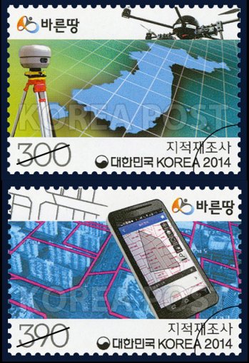
Korea 2014-03-20
On March 20, 2014 Korea Post issued two new stamps depicting a cadastral readjustment project taking place in the country. These fascinating stamps show a myriad of current high-tech devices used for surveying and mapping. The 300₩ stamp features what appears to be a GPS receiver of some type and a rotary aerial drone, whose intended use in this context, is probably aerial photography. In the background is a map graphic of the Korean peninsula. The 390₩ stamp features an Android smartphone, used as a mobile mapping terminal, with a cadastral map on the display showing what may be two different sets of parcel boundaries. In the background is what appears to be an oblique aerial image of an apartment complex overlaid with some vector GIS data depicting cadastral parcel boundaries. Both stamps are issued in the same joint sheet of 20 (4×5) format. A graphic of a satellite is shown in the upper right selvedge of the sheet. [ some geospatial colleagues in the Korean government pointed out this article, in Korean, which describes the project. another article in English was published in August 2013. this is not the first depiction of a smartphone on a stamp however it may be the first time where a map is shown on the display and the device’s intended use is for field-surveying. also, while this is not the first UAV/drone to be depicted on a stamp, we think this is the first time a rotary UAV has been shown on a stamp. we welcome any additional information and discussion on this very unique and timely cartophilatelic issue. — web admin ]
Portuguese Mini-sheet Commemorates 400th Anniversary of Pinto's "Pilgrimage"
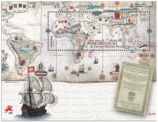
Portugal 2014-02-24
On February 24, 2014 Portuguese Post issued a souvenir sheet and single stamp to mark the 400th anniversary of the publishing of Fernão Mendes Pinto’s Pilgrimage (Peregrinação). Pinto was a a Portuguese explorer and writer and the work is considered an autobiographical account of his travels and voyages throughout India, Asia and the far east. The Pilgrimage was published posthumously in 1614 and many historians have doubted the truthfulness of his many interesting stories. The €3.00 sheet features a single long stamp. A world map “Mapa do Mundo de Antonio Sanches, 1623” is shown in the background and covers about 70% of the sheet. The lower 30% of the sheet is covered by hand writing of what could be journal entries. The stamp is in the upper right hand section of the sheet, covering the continents of Africa and Asia, as depicted in the antique world map. In the bottom left corner is a sailing ship of the period and in the bottom right corner is the cover page of the Pilgrimage. The single €1.00 issue features some of the same motifs from the sheet, however there is no map.

