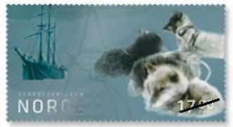
 Norway 2011-04 In April 2011, Norway Post issued a two stamp set commemorating the centennial of Roald Amundsen’s discovery of the South Pole, on December 14, 1911. The second stamp, 17.00 nok, shows Amundsen’s ship the Fram, along with a group of sled dogs. In the background of the stamp, a map of the polar route is slightly visible. The first stamp, 14.00 nok, in the set, shows a portrait of Amundsen, and a photograph of the team at the South Pole. Images of Amundsen’s journal are depicted in the background on the first stamp. There is no map on the first stamp. [ the date of issue is unclear from the Norway Post web site. –web admin ]
Digital Edition
A secure web page has been setup for downloading the current issue of the Journal and digital subscribers have that option instead of receiving it as an email attachment. Some of the digital subscribers were having problems receiving the email with such a large attachment, so this download page will solve that problem. Our Editor, Martin Oakes has contacted all of the members using email to verify their contact information, and record their options for receiving the digital edition.
Hardcopy Edition
Over the past couple of months the Officers have been investigating the use of a Print On Demand (POD) service to print the Journal for the hardcopy subscribers. During the summer we made a test printing of a sample issue using a new self-publishing web service from HP called MagCloud. MagCloud enabled us to create a commercial quality Journal, printed on demand with no up-front costs or minimum print runs. Its a fascinating service with a very easy to use interface. Other philatelic societies should definitely give it a try.
The officers were happy with the printing quality and production costs and wanted to give the hardcopy subscribers an opportunity to see an issue printed by MagCloud and receive their comments. Please send your comments to the Editor.
“We have been examining such options for a few months and the Officers feel that outsourcing the production of the Journal using a POD service is a win-win situation for both the hardcopy subscribers and also the Society,” said President David Wolfersberger. “We are sure you will be very happy with the printing quality and production of the MagCloud issue. When some of our digital subscribers see the quality of the new printing, they may want to change back to the hardcopy subscription plan!”
The October 2010 issue of TNCP has been printed by MagCloud. Our Editor, Martin Oakes, is doing the shipping of the issues to hardcopy subscribers the first few days of October. We are also considering additional options to make back issues available on MagCloud and more information will be announced later.
Closed Album: Lillian Kent 2009-06
 Lillian Kent I was saddened to learn that Lillian Kent, long time Society member and Secretary/Treasurer Emeritus had passed away on June 18, 2009 at the age of 91. Ms. Kent was born in Johnstown, Pennsylvania in 1917. Lillian was active in the Society for many years, and I am sure that many of our veteran members will remember her activities and contributions to the CartoPhilatelists.
“I remember Lillian — she was a geography teacher in Lowell , MA at that time. She had a special interest in polar maps,” wrote Society Treasurer Ed Vallery, “she sent me my first map stamps, and from then on, I was hooked on cartophilately.”
President Emeritus Miklos Pinther wrote, “Lillian and I became officers (treasurer & president) about the same time, in the beginning of 1986. Unfortunately, we never had a chance to meet personally, but of course, we corresponded and spoke on the phone frequently, dealing with Society matters. I knew she was a geographer who had assumed a bookkeeping job with a travel agency after her retirement. She did an excellent job as a treasurer and wrote several very fine articles for our journal. She impressed me as a modest person who meticulously carried out her tasks, someone who always showed great civility. I remember that Lillian was quite unhappy when the Society had to suspend its operations. I am sure she felt very gratified that she was an important connection to resurrecting our activities.”
As Miklos mentioned, Lillian carried on after the Society became dormant in 1995. She continued to compile new issues checklists which she graciously shared with me when I first began to update the Maps on Stamps Checklist. The updating work Lillian had done on the new issues saved much time, and eliminated the need to go back and cover those several years while the Society was inactive. She also maintained the funds remaining in the account, so we were able to have some “money in the bank” when the Society was restarted.
Our thanks go out to Ms. Kent for all of her contributions over the years to the CartoPhilatelic Society, and our sympathy to her son, Michael.
David Wolfersberger
November 2010
President
The CartoPhilatelic Society
[ During Ms. Kent’s association with the Society, she wrote a number of articles for the Carto-Philatelist Journal. The Society is working to make these available in the forth coming TNCP Journal and on the web site. Please check back in the coming month for more information. –web admin ]
A final declaration agreement between the Netherlands Antilles and the Netherlands went into force on October 10, 2010, completing the process of constitutional reform in the Antilles. Curaçao and St Maarten have become autonomous countries within the Kingdom of the Netherlands. Bonaire, St Eustatius and Saba will become special municipalities of the Netherlands. The change in autonomy has also been documented in the October 25th, 2010 edition of Linn’s Stamp News, page 2.
 Netherlands Antillies : Curaçao, Saint Maarten 2010-10-10 Mark Honig, the Society’s Vice President, who hails from the Netherlands, has sent these images of new stamps issued to mark the new autonomy. Three stamps were issued on October 10,2010, in denominations of 111c and 164c. All three stamps depict maps. The map of Curaçao shows the urban areas of the island in yellow. The map of St. Maarten shows both the French (north) and Dutch (south) zones of the island. Both capitals are shown in red. The final stamp shows the remaining non-autonomous Netherlands Antilles, after the declaration. On January 1, 2011, Curaçao and St. Maarten will begin to use a new currency, probably on a 1 to 1 parity with the present Netherlands Antilles Guilder. We can assume these stamps will change at that time, as these denominations will be incorrect. The small Caribbean Netherlands islands of Bonaire, Saba and St. Eustatius will use the US dollar from Jan 1, 2011. [thanks to Mark for the heads-up and fact checking! — web admin]
The 4th meeting of the CartoPhilatelic Society was held during the APS Stamp Show 2010 in Richmond VA, August 12 – 15, 2010. The Richmond show was extensive, with at least 150 dealers and over 900 exhibit frames.

Three members of the Society, attended the meeting in Richmond on August 14. Martin Oakes, the editor of the Society’s Journal demonstrated a new macro that he is developing that will allow users to integrate an updated Excel version of the Map on Stamps Checklist with the user’s personal copy of an older version. Sometime the user will annotate the checklist with notes and additional information. The macro will allow a smooth integration of the old and new Checklists without losing personal comments or creating duplicate entries.
Martin expects the macro to be completed by year-end. It was decided to issue Rev. 5 of the Checklist to coincide with the completion of the macro.
We also discussed the possibility of using MagCloud to print and distribute The New CartoPhilatelist. An actual test was carried out using MagCloud to produce the October 2010 issue. The group also discussed having the Checklist available to members online.
Article Number 12: “Bridge of Spies” on a Map Stamp
New Submission August 2010, Research, text and scans by Volker F. Woesner
With the recent spy exchange between the US and Russian governments, reminiscent of previous Cold War times, Volker introduces us to an interesting German map stamp. Read more to learn about this unique issue in the 12th Marginalia entry. –web admin
 “ Bridge of Spies ” Germany , 1998, sc1988 I do not know much about bridges for spies only. But I know that one of these bridges is featured on a map stamp. It is the “ GlienickeBridge ” near Berlin.
This bridge was one of the most famous bridges until 1989. It was the “ Bridge of Spies ” in times of the Cold War. The bridge crosses the Havel River/Iron Curtain between the former communist Potsdam and the free West Berlin .
Access to the bridge had only captured Russian or US spies. The bridge was built in 1907 and connected the city of Potsdam with the city of Berlin .
The Soviet Union on one side of the Iron Curtain and the US on the other side used this bridge to exchange captured spies during those times.
One of the most famous exchanges took place on February 10, 1962. The US exchanged the Russian spy Rudolf Abel for the pilot of the US reconnaissance plane U-2, Gary Powers, who was captured by the USSR .
The last big prisoner exchange on this bridge took place in 1986.
|
Welcome to the CartoPhilatelic Society Celebrating our 71st Year as a Society. Come and Join Us!
The CartoPhilatelic Society has entered our 71st year as a Society! In 1955 a group of philatelists with a keen interest in map stamps founded the CartoPhilatelic Society. Today we carry on their passion for map stamps in the collections we assemble and the research we conduct.
Come and join us as we look forward to the future!
Web Site Last Updated:
October 1, 2026

A one year term of membership for the CartoPhilatelic Society runs April 1 through
March 31. Unless you have pre-paid for multiple years, or already renewed you dues, your membership has expired at the end of March 2026
If you have not yet renewed, please continue to support the Society and renew your dues for the April 2026 through March 2027 term as soon as possible.

A big "Thank You!" to all those members who have recently renewed their membership! The CPS appreciates your continued support and donations.
Visit our Membership page for information.
|
|
 CPS Resource Centre